Plot Boundary by Forest Land: Cadastre, Fallen Wood and Fire Safety
A practical due-diligence guide to forest-edge plot boundaries, registry conflicts, fallen-wood rules and the fire-safety duties that continue after purchase.
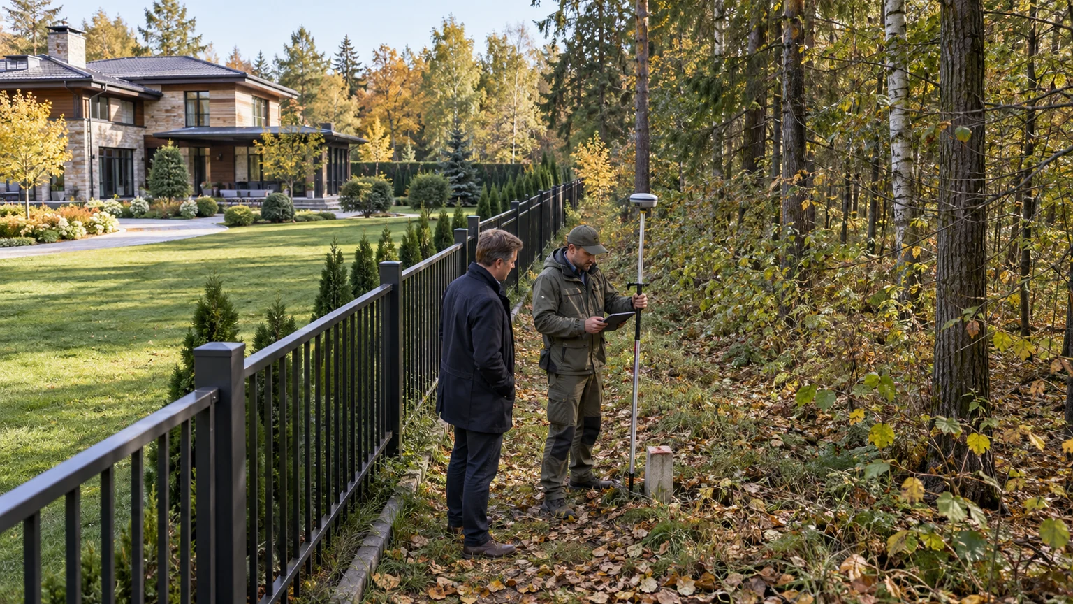
A plot adjoining woodland should be inspected as a boundary between legal and operating regimes, not merely as an attractive setting. The fence may not follow the EGRN coordinates, the strip beyond it may be state forest land, and routine removal of branches depends on where the work occurs and what legally counts as fallen wood. These issues tend to emerge during a survey, a fence relocation, a dispute with the forestry authority or preparation for the fire season—not during a summer viewing.
This guide concentrates on title, cadastral evidence and ongoing responsibilities. Daylight, moisture, wind and seasonal privacy are covered in the separate house-by-the-forest inspection guide. The distinction matters: an excellent forest view does not establish where private ownership ends or who may work beyond the fence.
Identify what the “forest” actually is
Trees beyond a plot may stand on state forest land, urban woodland, landscaped settlement land, a gated community’s common area, another private parcel or protected land. These settings can look identical while having different ownership, permissions and maintenance responsibilities.
Request the current EGRN extract for the property, its boundary plan and the community’s land documents. Where the adjoining cadastral number is known, identify that parcel too. Moscow Region’s Forestry Committee has described an online check for overlap between private parcels and state forest land, with a formal overlap certificate available. That is a valuable layer of evidence, but it does not replace an EGRN extract or a cadastral engineer’s review.
Keep three lines separate in the report:
- registered boundary: the coordinates recorded for the private parcel;
- occupied boundary: the fence, paths, drainage, lighting and maintained landscape on the ground;
- forest-land boundary: the adjoining land information held by the competent authority.
If they differ, do not move a fence or “correct” the area informally. Establish the parcel’s history, coordinate accuracy and whether the issue is a registry error, an overlap or occupation of land belonging to another party. A general claim that the forest-amnesty rules solve everything is not a legal conclusion for a specific property.
Complete the boundary check before a non-refundable deposit
Start with a fresh registry extract and the seller’s title instrument. Confirm that boundaries are established, the area and land category are consistent and the coordinates can be set out on site. Compare them with public and departmental mapping layers. Online maps flag risk; a qualified professional must make the transaction conclusion from current evidence.
- Obtain the EGRN extract and the seller’s underlying title document.
- Ask a cadastral engineer to review the polygon, neighbouring parcels and possible overlaps.
- Set out key boundary points and record the fence, buildings, roads and utilities.
- Obtain information about adjoining forest land and request formal clarification if an overlap appears.
- Compare the result with planning constraints using the separate protected-use-zone due-diligence method.
- Put every discrepancy into the legal and technical reports before payment becomes irreversible.
Inspect the apparently unused strip between the fence and the first trees. It may contain a drainage outlet, lighting cable, forest gate, compost, branch storage or landscaping. Plot every item and identify the legal basis for occupying the land. Long-standing everyday use does not itself prove ownership.
A fence is evidence of occupation, not title
In established communities, fences may follow old tracks, terrain or convenient trees rather than modern coordinates. A survey can reveal an offset years after construction. The buyer may inherit the obligation to surrender a strip, redirect stormwater or remove landscaping.
Confirm that retaining walls, gates, the security perimeter, an emergency route and external utilities fall within the proper land. Where community infrastructure follows the forest edge, request an ownership and maintenance diagram. The guide to entrance control and emergency access provides a useful companion check.
Describe a discrepancy in measurable terms: coordinate, approximate affected area, assets on the strip, adjoining owner and the document relied on by the seller. Counsel can then propose a real transaction condition—rectification before completion, a retention, a specific warranty or withdrawal—instead of accepting an informal assurance.
Fallen wood does not mean any timber in the forest
Moscow Region’s Forestry Committee explains that citizens may collect naturally fallen branches and trunks without roots for their own needs on state forest land, except at active logging sites, timber storage areas and protected territories where collection is restricted. Material must not be stored in the forest, and collection must not damage live trees, young growth, soil or ground vegetation.
This does not authorise felling a standing dead tree, dismantling a timber stack, taking a contractor’s logging residue or redesigning the neighbouring forest. A standing tree does not become collectable fallen wood simply because it is dry or leaning. Inspection and any intervention require the landholder and the applicable procedure. Trees within the private parcel should be addressed through a separate professional tree survey.
Before buying, ask who clears branches along the fence, where material is taken and why that party may enter the adjoining land. “The gardener always does it” is not a maintenance protocol. The management company should define its service area, contractor and escalation route to the forestry authority for a dangerous tree or blocked access.
The fire-protection strip is an operating duty
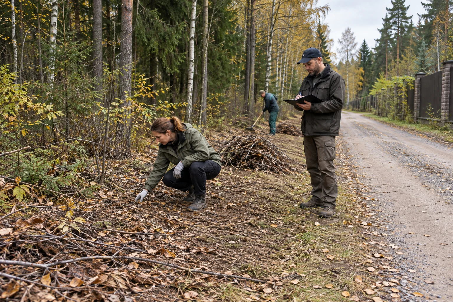
Current Russian fire-regime rules require people controlling land adjoining a forest, from snowmelt until sustained wet autumn weather or snow cover, to clear dry vegetation, crop and cutting residues, fallen wood, rubbish and other combustible material on a strip at least 10 metres from the forest. The alternative is a mineralised strip at least 1.4 metres wide or another compliant fire barrier. The current national text and any local restrictions must be checked when work is planned.
Dimensions alone do not prove an effective arrangement. Establish:
- the documented and physical line from which the forest edge is assessed;
- whose land carries the cleared strip and who may perform the work;
- whether fences, sheds, firewood, compost, wood mulch or dense undergrowth interrupt it;
- whether maintenance is possible without unauthorised heavy equipment entering the forest;
- where combustible material is lawfully removed and who accepts the result;
- how the edge is rechecked after wind, drought and autumn leaf fall.
Moving branches into a pile just behind the first trees is not a solution: the fire load remains at the boundary and storage in the forest conflicts with forestry guidance. A credible process ends with lawful removal or treatment in an authorised location.
A special fire regime changes ordinary use
Moscow Region issues seasonal documents covering fire-danger periods, special fire regimes and lists of settlements and gardening territories exposed to landscape fires. Status changes, so it should be checked before open-flame use, works or an event—not only during acquisition.
The owner needs a simple operating plan: the official source for current orders, a person responsible for boundary inspections, management and emergency contacts, accessible water, an unobstructed route and a family and staff notification procedure. Test whether gates open during a power failure, an appliance can turn and guest cars can be removed from the access road.
Do not assume that a pond, hydrant or storage tank is automatically a usable firefighting source. Its purpose, access and condition need evidence and testing. Likewise, a visually open gap among trees is not necessarily a fire barrier without confirmation of its design and maintenance.
Carry the findings into the transaction and handover
Include the forest boundary in the wider technical and legal due diligence of the country house. The technical appendix should show coordinates, photographs, fence position and infrastructure. The legal report should identify the adjoining land, overlaps, authority correspondence and unresolved issues.
If the community maintains the edge, read the management agreement. Does the common service area include the forest perimeter? Who funds and accepts the work, and what remains the individual owner’s duty? An unwritten practice may disappear when the management team changes.
Minimum handover evidence includes:
- current EGRN extract and boundary plan;
- boundary set-out record or survey showing the actual fence;
- result of the state-forest overlap check;
- forestry correspondence on dangerous trees or access, where relevant;
- seasonal clearance protocol and fire-barrier diagram;
- contract and acceptance records for the boundary contractor;
- emergency access, notification and water-access plan.
Forest-edge viewing checklist
- Compare the registered polygon, fence and actual occupation.
- Identify the status and authority for the adjoining wooded land.
- Plot every asset between the house and forest.
- Separate trees within the parcel from hazards beyond it.
- Confirm the fallen-wood rules and excluded areas.
- Walk the full fire-protection edge, not just the entrance.
- Review seasonal maintenance, removal of material and emergency access.
- Turn unresolved risks into completion conditions, not verbal promises.
The method is the same for homes along Rublevo-Uspenskoye Highway and Novorizhskoye Highway. A forest boundary adds durable value only when the view, title evidence and operating plan agree. The buyer should know the exact ownership line, what may be removed, who maintains the edge and how the property will respond to a landscape-fire threat.